
Everyone knows Mexico shares a long land border with the United States. But how much do you know about this dividing line and the vibrant, complex regions on either side of it?
To enhance your knowledge of the Mexico-U.S. border, here’s a quick crash course in 10 numbers.
This is the length in kilometers of the Mexico-U.S. border. The border runs from the Pacific coast in the Tijuana-San Diego area to the Gulf of Mexico at the mouth of the Rio Grande near Matamoros, Tamaulipas, and Brownsville, Texas. The length of the border in miles is 1,954.
This is the ranking of the Mexico-U.S. border in the list of the longest international land borders in the world.
The longest land border between two countries is that between the United States and Canada, measuring 8,891 kilometers.
Ten is also the number of states on the Mexico-U.S. border. Six of those states are in Mexico: Baja California, Sonora, Chihuahua, Coahuila, Nuevo León and Tamaulipas.

The other four are in the United States: California, Arizona, New Mexico and Texas.
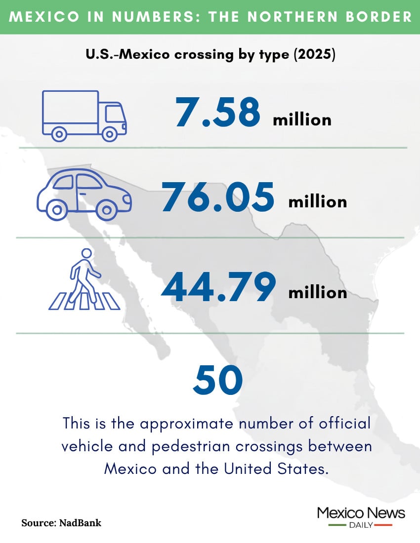
This is the approximate number of official vehicle and pedestrian crossings between Mexico and the United States.
In addition, there are seven rail crossings between the two countries. There is also a ferry crossing between Gustavo Díaz Ordaz, a municipality in Tamaulipas on the southern side of the Rio Grande, and Los Ebanos, Texas.
This is the number of trucks that entered the United States from Mexico in 2025. On average, 20,972 trucks entered the U.S. from Mexico every day last year. That figure is a testament to the importance of trade between Mexico and the United States, which are each other’s largest trade partners.
This is the number of personal vehicles that entered the United States from Mexico in 2025. The figure represents a decline of 1.1% compared to 2024. The busiest border crossing for personal vehicle entries to the U.S. last year was San Ysidro, where 15.27 million cars entered the country.
This is the number of pedestrians that crossed into the United States from Mexico in 2025. The figure represented an increase of 9.9% from 2024. The busiest border crossing for northbound pedestrians was San Ysidro, between Tijuana and San Diego, where 7.96 million people walked into the U.S. last year.
This is the number of U.S. Border Patrol encounters with migrants at the U.S.-Mexico border in fiscal year 2025, which ran from October 2024 to September 2025. The figure represents a decline of 84.5% compared to fiscal year 2024.
The Pew Research Center wrote in an article in February that “the 2025 total was the lowest in any fiscal year since 1970, according to historical data from the Border Patrol.”
This is the number of people living in the border region in both Mexico and the United States, according to 2020 data from the North American Development Bank (NAD Bank). Of that number, 19.3 million people live in 224 municipalities in Mexico that are within the NAD Bank’s border region jurisdiction. Just over 7.1 million people live in 41 U.S. counties that are within the bank’s jurisdiction (see map here).
This is the daily minimum wage, in Mexican pesos, in Mexico’s northern border region. The rate is 39.9% higher in the border region than in the rest of Mexico. The daily minimum wage in the northern border region is equivalent to around US $25 at the current exchange rate.
This is the percentage rate of Mexico’s IVA (value-added tax) in the northern border region. The IVA in the rest of the country is 16%.
Of course, many other numbers could be included in a “Mexico in Numbers” article on the Mexico-U.S. border. Let us know of any that come to mind!
Mexico News Daily